
Interview
620 Years of Seoul
By Choi Min-young
Interview with Lee Sang-koo,Kyonggi University
Yoo Suk-yeon, University of Seoul
One of the old sayings that best describes Seoul is a version of the “needle in a haystack:” “It is like looking for Mr. Kim in Seoul.” Aside from Kim being the surname of 20 percent of the people in Korea, this proverb also illustrates the huge population and spatial complexity of Seoul. This saying is as true today as it has been since the designation of Seoul as the capital of the Joseon Dynasty roughly 620 years ago. In this issue, two professors of architecture and urban planning and design share their thoughts on this megacity.
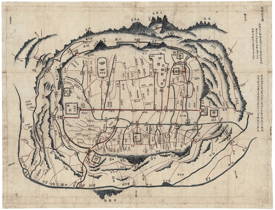
Map of the Walled Capital of Joseon produced in 1830 shows the royal palaces, street network, drainage system, and major buildings of the time. The red horizontal line drawn from the east to west gates in the wall marks today's Jongno street. The green line below it indicates the Cheonggyecheon Stream (photo courtesy of the Seoul Museum of History).
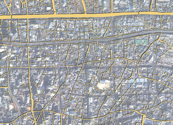
A satellite image of central Seoul overlaid with the Joseon-era streets marked in yellow.
With this map, Professor Lee Sang-koo has confirmed that the present street network mainly
conforms with the original streets, particularly the back streets formed along natural
water channels (photo courtesy of Lee Sang-koo).
Professor Lee Sang-koo
A Capital City in a Basin
Following the Goryeo era (918–1392), the Joseon Dynasty was founded in 1392 as the new authority on the Korean Peninsula. The founder of Joseon, Yi Seong-gye, immediately embarked on a search for sites for a capital of the new dynasty. Three candidates made it to the short list. The final choice was Hanyang, the central area of what is now Seoul.
“It is a common practice to place the seat of government on a site higher than the surrounding area. However, the capital of Joseon was constructed at Hanyang, a basin enclosed by ‘four inner mountains’—Baegaksan, Naksan, Namsan, and Inwangsan Mountains, which are again surrounded by four ‛outer mountains’, namely Bukansan, Yongmasan, Gwanaksan, and Deogyangsan Mountains. Toward the later Joseon period, commercial activities began to thrive along the Hanggang River and the urban space sprawled far beyond the original walled capital. The extension of the administrative area of Seoul in the 1960s, which essentially formed the boundaries of Seoul as we know them now, was still based on the original site of Hanyang. It is amazing that this decision from 620 years age to create the capital of Joseon in Hanyang was the starting point for the growth of Seoul into a megacity home to about 10 million people today.”
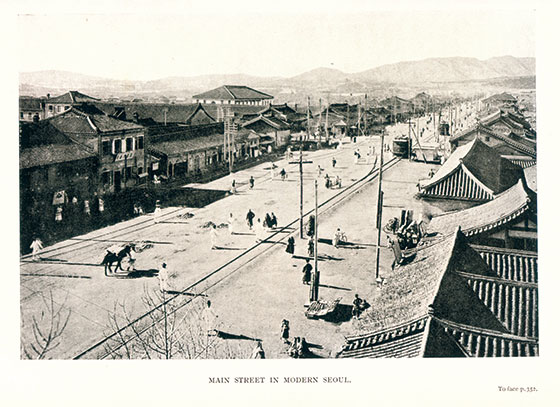
Jongno in 1911 (photo courtesy of the Seoul Museum of History)
(photo taken by Seo Heun-kang)
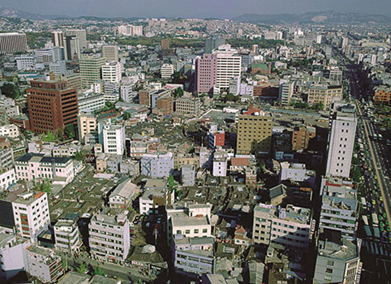
Jongno in 1983. Buildings were constructed facing different directions to match
the flow of water channels. This reflects the respect for nature underlying the shaping of
the urban space of Seoul (photo courtesy of the Seoul Museum of History).
Professor Lee considers that it was strategically wise of Joseon’s leaders to place the seat of government at Hanyang. There were geomantic advantages and Confucian considerations that underpinned the selection at the time, but it was a superb decision from today's perspective as well. Hanyang was located in the geographical center of the Korean Peninsula and therefore an ideal place for supporting political centralization. The nearby water channel of the Hangang River promoted the development of trade and commerce. The basin landform provided a natural fortress and contributed to preventing infiltration by enemies. Hanyang was endowed with optimal geographical features to become a capital city.
“Along the ridgelines of the four inner mountains were constructed a wall to encircle the capital. The wall was pierced in the four cardinal directions by large gates: Sukcheongmun (north gate), Heunginjimun (east gate), Sungnyemun (south gate), and Donuimun (west gate). The horizontal road running from the east to west gates, or Jongno, was the primary axis for the spatial composition of the capital and hence the everyday lives of people. With Jongno as a dividing line, the palace, office buildings, and high-end houses were set to the north, with residential areas for more humble people to the south.”
The bustling Jongno street that crosses Seoul today is the same street walked by the people of Joseon centuries ago. Memories of Hanyang remain alive at every corner.
“An excavation anywhere in Seoul reveals a Joseon street network that is little different from that of today. The city has grown into a forest of skyscrapers, but its spatial composition remains the same as was during the Joseon era. Seoul may have changed a great deal in the intervening centuries, but the change took place in a way that respects the city's historicity. For example, the current concrete bridges that connect the far banks of the Hangang River were not just randomly constructed: they were sited based on the locations of old Joseon river ports. The routes taken by boats crossing the river during the Joseon era have been converted into today's Hangang River bridges.”
Professor Lee Sang-koo. Crisscrossing the back streets of Seoul and recording the stories of the people living there is his life’s mission (photo taken by Jung Meen-young).
Memories of Alleys
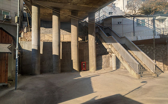
The urban space of Seoul is comprised of numerous back streets. Taking a few steps away from a boulevard can lead to a chain of alleys. Urban planning in Seoul was not about artificial efforts to change the given landscape. The existing mountain ridges, water channels, and other topographic features were respected to the fullest, to which people’s lives were gently added.
“People constructed their home on the flat lands along a waterway, these houses came to constitute a cluster, and between these areas were formed natural alleys. These alleys linked to others, and so on. In this sense, the alleys represent the lives of people who have lived there. What makes a city’s current state is a palimpsest of the times it has passed through and people who
have lived there. Rather than who designed a city and based on what ideology, it is the people living in a city who are responsible for shaping its identity.”
Professor Lee Sang-koo is conducting a meaningful project to update a mid-18th century map of Seoul to reflect modern Seoul. Through this careful comparative analysis, Professor Lee has confirmed that the old back streets marked on a map more than 200 years ago provided the underpinnings for the development of the global city of Seoul today.
“I would like to summarize the overriding principle that has shaped the urban space of Seoul in two words—nature and autonomy. Changing not a single thing about the given topography, people have independently developed the rules for living in Seoul. Natural features and social autonomy—these are what have supported the life of Seoul over the last 620 years.”
As much as the long boulevards of Seoul lined with high-rise buildings suggest the future of the city, the narrow streets that connect the large roads at countless points reflect the past and present of people's lives. The alleys are unwittingly winding, irregularly widened and narrowed, and can lead to unexpected dead-ends, just like the lives of the city’s people.
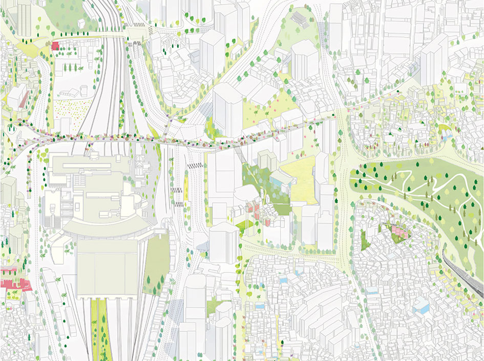
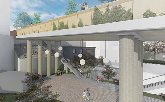
An old overpass near Seoul Station has gained a new breath of life as a public park called Seoullo 7017. Another urban regeneration project is underway to extend the vitality of the overpass-turned-park into adjacent back streets (photos courtesy of Yoo Suk-yeon).
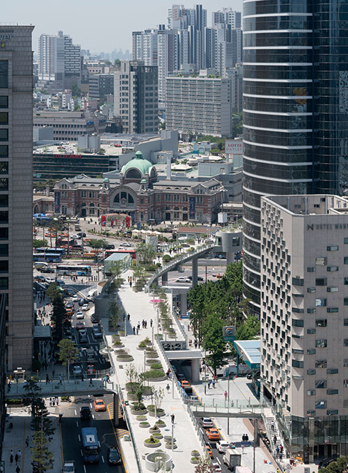
An old overpass constructed in 1970 near Seoul Station was reopened in 2017
as a public park called Seoullo 7017.It is one of the main urban regeneration
projects in Seoul (photo taken by Ossip van Duivenbode and provided by the Seoul
Metropolitan Government).
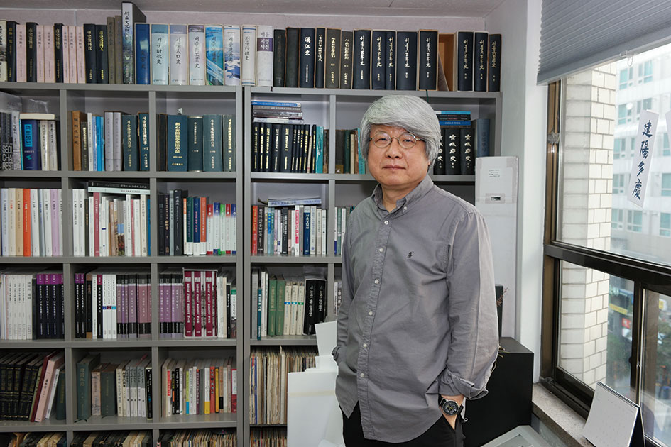
Professor Yoo Suk-yeon
From Historicity into Modernity
“In Seoul, historical layers of material and modern structures harmoniously intermingle. The capital of Joseon as an enclosed space within the Seoul City Wall has now become a megacity. It has grown into an international center and a complex organism.”
Seoul has lived through a long series of historic events. The city served as the seat of government for the dynasty that ruled the Korean Peninsula for 518 long years, and then served as a springboard for Japan's imperialist aspirations against China. The Korean War soon followed, and the reckless processes of industrialization and urbanization occurring afterwards put great strains on the city. Seoul has embraced the physical consequences of all these historical events.
“Seoul is unparalleled in its dynamism, which does not admit a distinction between day and night. Seoul is active at any hour, it can be lit up anywhere, and it is open everywhere. At the same time, it is one of the safest cities in the world. People are full of potential and vitality, and they live diverse lifestyles.”
Reconstruction efforts following the Korean War were combined with the modernization projects that started in the 1960s and set Seoul on a process of transformation. The inflows of population continued, and the city made its mark on the international map with the 1988 Seoul Summer Olympics. Seoul changed with the bustling times. There came an incessant flow of redevelopment projects in every corner of the city. During the bouts of redevelopment concentrating on the complete demolition of buildings, cultural and historical resources were sacrificed. While the gap between rich and poor widened, the population of Seoul reached its maximum carrying capacity and the areas surrounding the city started to accommodate people spilling over from the capital. As part of the efforts to decentralize the national population, government and public offices were relocated to other parts of the country.
“Over its 628 years as the capital of Korea, the organism of Seoul has gained some dead cells at certain places through its area. This is manifested by such symptoms as a declining population, dwindling opportunities for employment, and an increasing number of aging buildings. The solution for these problems is urban regeneration. An urban regeneration project should be carried out based on a systematic plan and in reflection of the physical scale and sociocultural characteristics of the area concerned.”
In addition to the rather drastic prescriptions of the past, such as redevelopment and reconstruction, urban regeneration is now available as an option to revitalize declined areas of a city.
“Every area shows the marks of time and the memories of people. These places come together to comprise the history of a city. Now we are rethinking the long-held approach to old urban space. Dismantling them and constructing new ones might not be ideal and might not be the only option. The competitiveness of a city stems from its sociocultural context linking the present to its past and future. As one of the ways to actualize this, urban regeneration must be seriously considered these days. Now we are starting to give due attention to the history and culture of the area concerned.”
Jojokdeung, or “lanterns to light the feet,” used to light a path at night.
A vertical handle is connected to a round body with an opening at the bottom.
(photo taken by Seo Heun-kang)
A portable lamp with a wooden frame. The four sides can be
opened by pulling the knob affixed to their lower section.
(photo taken by Seo Heun-kang)
A New Breath for Alleys
Reconstruction efforts following the Korean War were combined with the modernization projects that started in the 1960s and set Seoul on a process of transformation. The inflows of population continued, and the city made its mark on the international map with the 1988 Seoul Summer Olympics. Seoul changed with the bustling times. There came an incessant flow of redevelopment projects in every corner of the city. During the bouts of redevelopment concentrating on the complete demolition of buildings, cultural and historical resources were sacrificed. While the gap between rich and poor widened, the population of Seoul reached its maximum carrying capacity and the areas surrounding the city started to accommodate people spilling over from the capital. As part of the efforts to decentralize the national population, government and public offices were relocated to other parts of the country.
Professor Yoo Suk-yeon hopes to create an urban space where visitors and residents can freely intermingle and everyone can find a source of vitality near where they live (photo courtesy of Yoo Suk-yeon).
“Over its 628 years as the capital of Korea, the organism of Seoul has gained some dead cells at certain places through its area. This is manifested by such symptoms as a declining population, dwindling opportunities for employment, and an increasing number of aging buildings. The solution for these problems is urban regeneration. An urban regeneration project should be carried out based on a systematic plan and in reflection of the physical scale and sociocultural characteristics of the area concerned.”
In addition to the rather drastic prescriptions of the past, such as redevelopment and reconstruction, urban regeneration is now available as an option to revitalize declined areas of a city.
“Every area shows the marks of time and the memories of people. These places come together to comprise the history of a city. Now we are rethinking the long-held approach to old urban space. Dismantling them and constructing new ones might not be ideal and might not be the only option. The competitiveness of a city stems from its sociocultural context linking the present to its past and future. As one of the ways to actualize this, urban regeneration must be seriously considered these days. Now we are starting to give due attention to the history and culture of the area concerned.”
Text by Choi Min-young
Photos by the Seoul Museum of History, the Seoul Metropolitan Government, Lee Sang-koo, Yoo Suk-yeon and Jung Meen-young

서울, 620년의 도시
인터뷰: 이상구(Lee Sang-koo) – 경기대학교 건축학과 교수
유석연(Yoo Suk-yeon) – 서울시립대 건축학과 교수
한국 속담에 ‘서울에서 김서방 찾기’라는 말이 있다. 서울은 한국에서 인구가 가장 많고, 김씨는 한국에서 가장 많은 성이다. 이러니 옛날에는 서울에서 김서방을 찾는 일은 사실상 불가능에 가까운 일이었다. 물론 지금은 찾을 수 있을 거다. 서울은 세계에서 손꼽히는 발달된 인프라를 자랑하는 곳이기 때문이다.
이상구 교수 인터뷰
조선, 네 개의 산이 둘러싼 분지에 도읍을 정하다
한반도를 통치하던 고려(918 – 1392)가 멸망하고, 조선(1392 – 1910)이라는 새로운 국가가 등장한다. 조선을 건국한 태조 이성계는 조선의 수도를 정하기 위해 적합한 곳을 물색하였고, 세 곳의 후보지 가운데 조선이 선택한 도읍지는 한양이었다. 지금의 서울이다. “세계적으로 도시의 입지를 평지로 정하는 것이 일반적이지만, 조선의 선택은 달랐습니다. 백악-인왕산-남산-낙산으로 이어지는 내사산(內四山)에 둘러싸인 한양을 도읍지로 정한 것이죠. 이는 삼국시대 이전부터 우리나라 도시에 내재된 독특한 유전자입니다. 조선 후기에 이르면 물자가 들어오는 길목인 마포, 서강, 용산, 두모포 등 한강변에 상업지대가 형성되면서 도성 밖으로 시가지가 확산됩니다. 1960년 대에 시역 확장으로 서울시가 크게 확대되는데, 이는 이미 조선 시대의 한양도성을 중심으로 자연적으로 형성되어 있던 북한산-덕양산-관악산-용마산의 외사산(外四山)으로 둘러싸인 분지에 잘 자리잡고 있다는 것을 확인할 수 있습니다. 620여 년 전의 선택은 오늘날 서울이 자리잡을 공간과 도시의 기본 구조 형성, 그리고 수백 년 후 천만 명 이라는 인구까지 수용할 수 있었던 놀라운 결정이었던 거죠.”
이상구 교수는 조선이 매우 현명하고 탁월한 선택을 한 것이라고 생각한다. 당시에 풍수지리나 유가적 합리론 등 도읍 선정을 위한 다양한 논의가 있었겠지만, 국토의 중심에 위치하여 권력이 중앙으로 집중될 수 있었던 점, 한강이라는 수운이 산업 전반에 유용하게 사용될 수 있었던 점, 분지로 이루어져 외부 침입을 미리 차단할 수 있었던 점 등 한양은 지형적으로 사실상 최고의 조건을 갖추고 있었다. “내사산의 능선을 따라 성곽이 축조됩니다. 그리고 네 개의 지점에 성문(돈의문(敦義門, 서대문), 숙청문(肅淸門, 북대문), 숭례문(崇禮門, 남대문), 흥인지문(興仁之門, 동대문))이 만들어지죠. 동-서 방향이 평지로 이루어져 서대문과 동대문을 연결하는 ‘종로’가 도시 생활의 주생활 축으로 자리매김 합니다. 환경적으로 가장 좋은 조건을 갖춘 북쪽은 궁궐, 관청, 고급 주택가가 형성되었고, 남쪽은 서민주택가가 들어섭니다. 이 네 구역이 만나는 중앙 지점은, 상업적 기능을 포함한 도시의 중심으로서 남촌과 북촌의 구조가 형성됩니다.”
우리가 지금 거니는 서울의 종로나 북촌 등지는 조선 시대를 살았던 당시의 시민들의 생활상이 고스란히 반영된, 한양의 종로이자 북촌인 셈이다. 그때와 다름없이 지금도 사람들이 모여들고, 반짝인다. “서울의 땅을 파내면 지금과 구조상 별반 다르지 않은 옛 거리가 드러납니다. 땅 위에 올라 서있는 건물들은 다르지만, 이를 묶고 있는 구조나 길, 필지 등은 그대로인 거죠. 대규모의 집단적 개발이 아닌 이상, 건물이 하나씩 바뀌고, 도로의 일부를 정비하는 등 조금씩 조금씩 변해왔기 때문에 공간의 역사성이 유지될 수 있었습니다. 이를테면 지금 한강에 놓인 다리들은 새로 길을 뚫어 연결한 것이 아니라 옛날 나루터까지 뻗어있던 길들을 이제 다리로 연결한 것뿐입니다. 북쪽과 남쪽을 오가던 옛 뱃길이 고스란히 다리가 된 거죠.”
서울의 역사는 골목의 역사
서울은 많은 골목으로 이루어져 있다. 대로에서 조금만 안쪽으로 들어가면 여지 없이 좁은 골목이 이어진다. 도시를 건설하기 위해 구획을 설계하거나 수로를 만드는 등 계획 하에 건설된 것이 아닌 능선, 물줄기, 언덕 등 지형적 특성을 고스란히 받아들이고 그 위에 그저 삶을 얹은 것이 서울의 특징이다. “물길을 따라 난 평지 위에 집을 짓고, 그 집들이 모여 골목을 형성하고, 그 골목에서 또 새로운 골목을 내면서 쌓아온 자연적인 질서는, 실제 거기서 살아온 주민들이 만들어낸 삶의 흔적이자 문화적 양식입니다. 도시란 결국 시간의 산물입니다. 최초에 누가 이 도시를 설계했고, 어떤 사상을 배경으로 했는지 그런 정보보다 그 곳에서 살며 만들어온 사람들의 힘, 그것이 더 중요하죠.”
이상구 교수는 18세기 중기의 지도를 지금과 매개인 20세기 초기의 지도를 근거로 현대화 하는 작업을 통해 서울의 골목 형태를 구체적으로 살피고 있다. 200여 년 전의 지도에 표시된 옛길이 지금껏 살아남아 서울이라는 세계적인 도시의 바탕이 되었음을 한 번 더 증명해 낸 것이다.
“저는 서울의 도시적 질서를 ‘자연과 자율’이라고 표현합니다. 미세지형까지도 훼손하지 않고, 주어진 땅 안에서 발견한 질서를 구조화하며 형성해온 도시니까요. 자연이 가진 질서와 사회의 자율적인 힘이 서울의 620년을 지탱한 것이죠. 이것이 서울의 정신입니다.”
만약 당신이 시원하게 쭉 뻗은 대로에서 미래의 서울을 만났다면 그 사이사이마다 가늘게 뻗어있는 골목에 접어들어보라. 골목은 깊숙이 접어들수록 제멋대로 휘고, 그 폭은 불규칙적으로 늘고 줄며, 때론 느닷없이 막다른 길이 드러나기도 한다. 우리들의 삶은 어떠한가. 그 골목과 다르다 할 수 있을까. 수많은 삶이 숱하게 넘어지고 울고 웃으며 디뎠을 서울의 단단함이 수많은 골목길에 어려있다. 지금도 마찬가지다.
유석연 교수 인터뷰
서울, 근대 도시로 성장하다
“현대의 서울은 사람들이 오랜 세월 동안 만들어온 곳이자 인공적으로 만든 신도시가 공존합니다. 역사 도심인 한양도성에서 하나의 도시 국가로 여겨질 수준의 광대한 도시가 되었습니다. 세계도시이자 정체성을 한 마디로 규정할 수 없는 생물처럼 다채롭게 성장했습니다.”유석연 교수의 말처럼, 서울은 참 많은 변곡점을 지났다. 518년 간 한 국가를 통치한 왕조가 군림했고, 주권을 빼앗은 침략국의 대륙 진출을 위한 거점이 되기도 했다. 전쟁을 겪고 급격한 산업화에 몸살을 앓았고, 폭증하는 인구를 감당하느라 진땀을 흘려야 했다. 고대 문명 도시처럼 옛 모습을 지켜내는 일보다 쏟아지듯 흘러가는 시대의 흐름을 고스란히 품어주던 서울에 우리는 참 의지도 많이 했다. “세계의 어느 곳에서도 이런 도시를 찾기 어렵습니다. 밤낮 없이 역동적이고, 어딜 가도 환히 불이 켜져 있죠. 문도 활짝 열려있고요. 그러면서도 전세계에서 가장 안전한 도시 중 하나이죠. 사람들에게서는 잠재력과 활력이 뿜어져 나오고, 곳곳에서 저마다의 마을을 이루어 살아가는 도시, 오늘의 서울입니다.”
한국전쟁으로 황폐해진 도시의 재건과 1960년대부터 산업화가 맞물리면서 서울은 변화를 시작한다. 유입인구는 꾸준히 늘었고, 1988 서울올림픽을 통해 세계적인 도시로써의 신고식도 마쳤다. 시간은 급히 흘렀고, 사람들은 정신 없이 낮과 밤을 맞이하며 하루하루를 살았다. 그러는 사이 서울 곳곳은 기존 시가지의 대단위 철거를 통한 재개발이 쉼 없이 이어졌다. 역사와 문화자원을 희생해야 했다. 사람들의 격차는 점점 더 벌어졌다. 더 이상의 인구를 수용할 수 없어 인접 수도권으로까지 삶의 범위가 확장되었고, 서울에 집중된 정부청사와 공공기관들을 전국에 분산시키는 등 여러 묘수를 찾아내야 했다.
“수도로서 628년이라는 세월을 버티면서 서울은 곳곳에 시간이 중첩된 오래된 도시 조직을 갖게 되었습니다. 특정 지역에 인구 감소, 일자리 감소, 노후건축물이 증가하게 되면 도시 재생이 필요한 지역으로 여기고, 도시재생활성화계획을 수립하게 됩니다. 도시재생사업은 그 지역의 규모와 특성에 맞추어 진행됩니다.”
과거에는 노후 지역에 ‘재개발’, ‘재건축’ 등의 극단적인 처방을 내렸지만 이제는 쇠퇴한 지역을 살리는 ‘도시 재생’이라는 또 하나의 선택지가 늘었다.
“모든 곳은, 시간이 쌓아 올린 자국을 가지고 있습니다. 그 안에 사는 사람들의 삶 자체가 도시의 역사죠. 재개발로 인해 모든 것을 흔적 없이 지우고 새로운 건물을 올리는 일이 마냥 옳지만은 않다는 것을 이제 우리도 알게 된 겁니다. 도시의 경쟁력이란, 그 도시의 어제와 내일을 관통하는 맥락(context)입니다. 이것을 지키고, 다시 살려내기 위해 도시 재생이 시대의 화두로 대두되었고, 비로소 그 지역의 역사와 이야기에 귀를 기울이게 된 거죠.”
도시 재생, 골목에 호흡을 불어넣는 일
서울시는 2017년 서울로 고가도로를 시민들이 즐기며 걸을 수 있는 ‘서울로 7017’로 재개통했다. 1970년에 준공한 이래 40년 가까이 철도로 단절된 지역들을 연결해 왔던 서울로 고가도로는 2006년 안전성의 문제로 철거 판정을 받았다. 하중을 견디기엔 고가 도로는 너무 낙후되었고, 이제는 되레 교통 흐름을 방해하고 있다는 진단을 받은 것. 하지만, 차량의 하중은 견디지 못하더라도 사람들이 걷기에는 문제 없는 이 고가도로는 오랜 논의 끝에 사람을 위한 길로 다시 태어났다. 그리고 서울로7017을 중심으로 중림동, 서계동, 후암동, 회현동의 더 많은 골목으로 녹색 보행길이 확장되는 사업이 유석연 교수를 중심으로 진행 중이다. “서울시 공공건축가로 구성된 7명의 골목건축가들이 이 고가 도로로부터 이어진 7개의 골목들을 함께 디자인 했습니다. 명동, 남대문시장 등 도심과 끊어진 지역들을 ‘서울로 7017’과 연결해서 조그만 골목에도 사람들의 온기가 닿을 수 있게 한 것이죠. 봉제산업 등 지역 경제 활성화는 물론, 각 골목이 가진 매력, 그리고 사람 사는 이야기를 모두와 공유하고자 되살리는 것이 가장 큰 목표입니다.”
서울은 다른 나라에 비해 일상생활에 근접한 공원이나 광장이 많지 않고, 그래서 그런 문화랄 것도 딱히 없다. 대신 산과 강, 크고 작은 구릉지는 사람들이 걷고, 이야기하며 어울려 살아가기에는 더없이 적합했고, 특히 한국 사람들의 정서와 잘 맞았다.
“구릉지의 좁은 골목들은 복잡해 보이지만 굽이굽이 우리가 살아온 오래된 일터와 삶터를 담고 있습니다. 사람들의 스케일(Human scale)에 맞는 환경으로 위압적이지 않고 따뜻한 문화환경으로 되살아나기 적합하죠. 서울의 재생 목표는 그 매력이 보존되거나 도드라지게, 그리하여 사람들이 모여들고 정착할 수 있게 하는 것입니다.”
노후 지역을 ‘철거’가 아닌 ‘재생’하는 것을 목표로 하게 되면서 우리는 도시의 신기능보다 본래 가지고 있던 정겨움에 주목하게 됐다. 오래 전부터 그 곳에 살았던 원주민들의 삶에 귀를 기울이고, 젊은이와 문화예술인들이 꿈을 펼칠 수 있는 배경을 제시한다. 주민과 방문객이 서로 어우러지고, 누구나 자신이 살아가는 그 터에서 활력을 찾길 바란다.
다양한 삶의 형태를 가진 사람들이 모여 저마다의 삶을 기쁘게 살아가는 곳, 오늘도 서울은 어제를 쌓은 만큼 내일로 나아간다.
Text by 최민영